Tugna:Kingdom of Numidia-02.png

Tiddi n azaraskan agi : 800 × 346 iferdisen n tugna. Tibuda nniḍen : 320 × 138 iferdisen n tugna | 640 × 277 iferdisen n tugna | 1 024 × 443 iferdisen n tugna | 2 246 × 971 iferdisen n tugna.
Afaylu aneṣli (2 246 × 971 pixel, tiddi n ufaylu: 495 KB/KO, anaw n MIME: image/png)
Agzul
| Aglam |
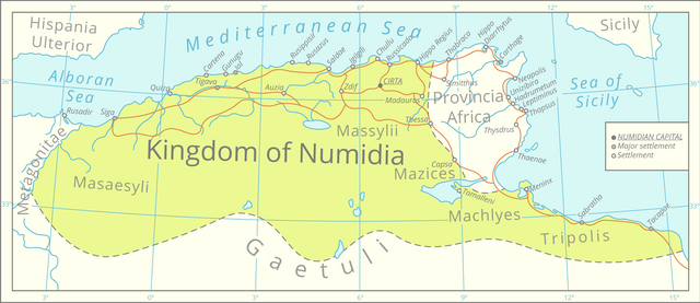
English: This map was assembled using the boundaries of this map, Roman road data from this [1] dataset, river and lake data from the Pergamon Atlas as well as settlement significance from the Barrington Atlas.
The graphics were assembled in QGIS and processed in Adobe Illustrator. All data is projected in the Lambert azimuthal equal-area projection. |
| Azemz | |
| Aɣbalu | Amahil udmawan |
| Ameskar | Cattette |
Turagt
Moi, en tant que détenteur des droits d’auteur sur cette œuvre, je la publie sous la licence suivante :
Ce fichier est disponible selon les termes de la licence Creative Commons Attribution 4.0 International.
- Ɣuṛ-k tilelli:
- i beṭṭu – akken ad tneɣleḍ, ad tzuzreḍ neɣ ad tebḍuḍ amahil-agi
- i uṣeggem – i uṣeggem n umahil
- Ddaw n tiwtilin-agi:
- bab – Yessefk ad d-bedreḍ isem n umeskar aneṣli s wudem yettwammlen sɣuṛ ameskar n umahil neɣ bab n izerfan i k-imudden tasiregt (mačči s wudem yemmalen am akken yettmuddu-yak afus neɣ yeqbel aseqdec-it n umahil).
Amazray n ufaylu
Senned ɣef yiwen azmez d usrag iwakken ad ẓṛeḍ afaylu aken yella deg imir nni.
| Azemz/Ssaɛa | Aqmamaḍ | Iseggiwen | Amseqdac | Awennit | |
|---|---|---|---|---|---|
| Lux a | 30 Meɣres 2021 à 00:26 | | 2 246 × 971 (495 KB/KO) | Cattette | Uploaded own work with UploadWizard |
Aseqdec n ufaylu
Asebter agi teseqdac afaylu agi :
Aseqdec n ufaylu amatu
Iwikiyen-agi-nniḍen seqdacen afaylu-agi:
- Aseqdec ɣef ar.wikipedia.org
- Aseqdec ɣef ast.wikipedia.org
- Aseqdec ɣef az.wikipedia.org
- Aseqdec ɣef bs.wikipedia.org
- Aseqdec ɣef ca.wikipedia.org
- Aseqdec ɣef cs.wikipedia.org
- Aseqdec ɣef de.wikipedia.org
- Aseqdec ɣef el.wikipedia.org
- Aseqdec ɣef en.wikipedia.org
- Aseqdec ɣef eo.wikipedia.org
- Aseqdec ɣef fa.wikipedia.org
- Aseqdec ɣef fi.wikipedia.org
- Aseqdec ɣef fr.wikipedia.org
- Aseqdec ɣef fy.wikipedia.org
- Aseqdec ɣef gl.wikipedia.org
- Aseqdec ɣef ha.wikipedia.org
- Aseqdec ɣef ia.wikipedia.org
- Aseqdec ɣef ja.wikipedia.org
- Aseqdec ɣef ko.wikipedia.org
- Aseqdec ɣef lt.wikipedia.org
- Aseqdec ɣef lv.wikipedia.org
- Aseqdec ɣef mk.wikipedia.org
- Aseqdec ɣef pl.wikipedia.org
- Aseqdec ɣef rue.wikipedia.org
- Aseqdec ɣef sl.wikipedia.org
- Aseqdec ɣef www.wikidata.org