Tugna:Scandinavian States.svg

Taille de cet aperçu PNG pour ce fichier SVG : 636 × 599 iferdisen n tugna. Tibuda nniḍen : 255 × 240 iferdisen n tugna | 509 × 480 iferdisen n tugna | 815 × 768 iferdisen n tugna | 1 087 × 1 024 iferdisen n tugna | 2 174 × 2 048 iferdisen n tugna | 1 090 × 1 027 iferdisen n tugna.
Afaylu aneṣli (Afaylu SVG, tabadut n 1 090 × 1 027 pixel, lqedd : 537 KB/KO)
| Aglam |
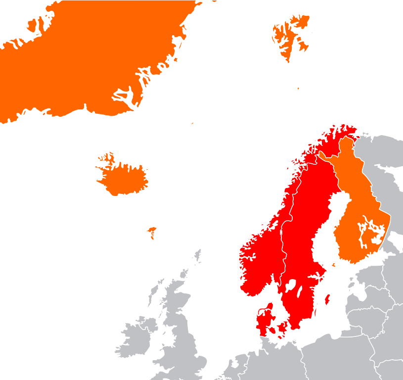
English: Map showing two of the common definitions of "Scandinavia"; a cultural, historical and ethno-linguistic region in northern Europe:
the most common usage: the three monarchies; Denmark, Norway and Sweden
an extended usage: including Finland, Iceland and the Faroe Islands
Русский: Карта показывает страны Северной Европы:
Страны Скандинавии: Дания, Норвегия и Швеция
Другие страны: Финляндия, Исландия, Гренландия и Фарерские острова |
| Azemz | (UTC) |
| Aɣbalu | |
| Ameskar |
|
| Cette image a été retouchée, ce qui signifie qu'elle a été modifiée par ordinateur et est différente de l'image d'origine. L'image d'origine se trouve ici : Location European nation states.svg:
|
Moi, en tant que détenteur des droits d’auteur sur cette œuvre, je la publie sous les licences suivantes :
| Afaylu-agi yella ddaw n tewtilin n turagt Creative Commons Attribution-Share Alike 3.0 Unported. | ||
| ||
| Ce bandeau de licence a été ajouté à ce fichier dans le cadre de la procédure de mise à jour des licences des images sous GFDL. |

|
Ɣuṛ-k tasiregt akken ad tneɣleḍ, ad tzuzreḍ neɣ ad tesnifleḍ isemli-agi akken yella di tewtilin n GNU Free Documentation License lqem 1.2 neq yal lqem amaynut i d-yeffɣen sɣuṛ Free Software Foundation, s war abeddel di tgezmiyin, s war aḍris deg usebter amenzu n tdulineɣ s war aḍris deg usebter aneggaru n tduli. Amedya n turagt yedda deg tgezmi ittusemman GNU Free Documentation License. |
Tzemreḍ ad ferneḍ yiwet seg turagin-agi.
Journal des téléversements d’origine
This image is a derivative work of the following images:
- File:Location_European_nation_states.svg licensed with Cc-by-sa-3.0-migrated, GFDL
- 2010-10-09T15:55:16Z LX 2045x1720 (748293 Bytes) Reverted sockpuppet edits to version as of 15:03, 11 November 2009
- 2010-10-02T06:27:34Z Lartyo 2045x1720 (730891 Bytes) Reverted to version as of 20:37, 18 October 2009
- 2009-11-11T15:03:57Z NuclearVacuum 2045x1720 (748293 Bytes) minor
- 2009-11-11T14:59:54Z NuclearVacuum 2045x1720 (733426 Bytes) territorial fixes
- 2009-10-18T20:37:51Z NuclearVacuum 2045x1720 (730891 Bytes) several countries did not include all its territories
- 2008-12-04T00:44:42Z Ssolbergj 2045x1720 (726069 Bytes) Kosovo
- 2008-06-20T13:09:36Z Ssolbergj 2045x1720 (724181 Bytes) Reverted to version as of 00:57, 12 June 2008
- 2008-06-19T17:59:14Z Ssolbergj 2045x1720 (719110 Bytes) {{Information |Description= |Source= |Date= |Author= |Permission= |other_versions= }}
- 2008-06-12T00:57:39Z Ssolbergj 2045x1720 (724181 Bytes) {{Information |Description={{en|1=SVG map of Europe. Borders of nation states.}} {{no|1=SVG-kart over Europa. Nasjonstatlige grenser.}} |Source=[[:Image:Location Spain EU Europe 1.svg]] |Author=[[:en:User:Ssolbergj|Ssolbergj]
Téléversé avec derivativeFX
Amazray n ufaylu
Senned ɣef yiwen azmez d usrag iwakken ad ẓṛeḍ afaylu aken yella deg imir nni.
| Azemz/Ssaɛa | Aqmamaḍ | Iseggiwen | Amseqdac | Awennit | |
|---|---|---|---|---|---|
| Lux a | 4 Tuber 2011 à 19:05 | | 1 090 × 1 027 (537 KB/KO) | Pic-Sou | greenland belongs to Denmark... |
| 10 Ctember 2011 à 04:51 |  | 1 090 × 1 027 (536 KB/KO) | Citypeek | Removed the text in the svg-file | |
| 8 Ctember 2011 à 16:50 |  | 1 337 × 1 025 (535 KB/KO) | Citypeek | {{Information |Description={{en|1=SVG map of Europe. Borders of nation states.}} {{no|1=SVG-kart over Europa. Nasjonstatlige grenser.}} {{sv|1=SVG-karta över Europa. Europa markerat med mörkgrått. Nationsgränser dragna i vitt.}} |Source=*[[:File:Locat |
Aseqdec n ufaylu
Asebter agi teseqdac afaylu agi :
Aseqdec n ufaylu amatu
Iwikiyen-agi-nniḍen seqdacen afaylu-agi:
- Aseqdec ɣef ar.wikipedia.org
- Aseqdec ɣef el.wikipedia.org
- Aseqdec ɣef en.wikipedia.org
- Aseqdec ɣef fr.wikipedia.org
- Aseqdec ɣef he.wikipedia.org
- Aseqdec ɣef hy.wikipedia.org
- Aseqdec ɣef it.wikipedia.org
- Aseqdec ɣef ja.wikipedia.org
- Aseqdec ɣef ml.wikipedia.org
- Aseqdec ɣef ru.wikipedia.org
- Aseqdec ɣef sr.wikipedia.org
- Aseqdec ɣef uk.wikipedia.org
- Aseqdec ɣef ur.wikipedia.org
- Aseqdec ɣef vi.wikipedia.org
- Aseqdec ɣef war.wikipedia.org