Tugna:Almohads1200.png

Tiddi n azaraskan agi : 800 × 497 iferdisen n tugna. Tibuda nniḍen : 320 × 199 iferdisen n tugna | 640 × 398 iferdisen n tugna | 846 × 526 iferdisen n tugna.
Afaylu aneṣli (846 × 526 pixel, tiddi n ufaylu: 19 KB/KO, anaw n MIME: image/png)

|
Cette image (de type historical map) devrait être recréée dans un format vectoriel, en tant que fichier SVG. Cela offrirait plusieurs avantages : voir Commons:Media for cleanup pour plus d'informations. Si une version SVG de cette image est déjà disponible, merci de bien vouloir l'envoyer. Après cela, remplacez ce modèle par {{vector version available|nouveau nom d'image.svg}}.
|
Agzul
| Aglam |
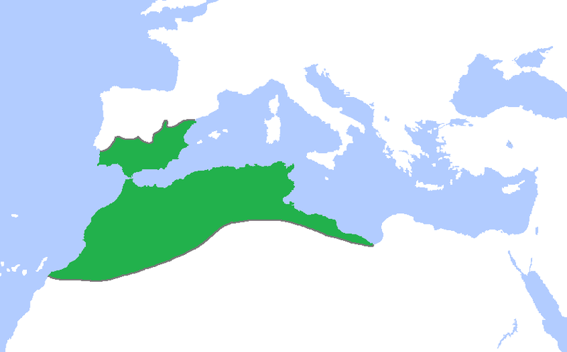
English: Locator map of the Almohad dynasty at its greatest extent, c. 1200.
(Partially based on Atlas of World History (2007) - The World 1000-1200, map) |
| Azemz | |
| Aɣbalu | Amahil udmawan |
| Ameskar | Gabagool |
Turagt
Moi, en tant que détenteur des droits d’auteur sur cette œuvre, je la publie sous la licence suivante :
Ce fichier est disponible selon les termes de la licence Creative Commons Attribution 3.0 Non transposée.
- Ɣuṛ-k tilelli:
- i beṭṭu – akken ad tneɣleḍ, ad tzuzreḍ neɣ ad tebḍuḍ amahil-agi
- i uṣeggem – i uṣeggem n umahil
- Ddaw n tiwtilin-agi:
- bab – Yessefk ad d-bedreḍ isem n umeskar aneṣli s wudem yettwammlen sɣuṛ ameskar n umahil neɣ bab n izerfan i k-imudden tasiregt (mačči s wudem yemmalen am akken yettmuddu-yak afus neɣ yeqbel aseqdec-it n umahil).
Amazray n ufaylu
Senned ɣef yiwen azmez d usrag iwakken ad ẓṛeḍ afaylu aken yella deg imir nni.
| Azemz/Ssaɛa | Aqmamaḍ | Iseggiwen | Amseqdac | Awennit | |
|---|---|---|---|---|---|
| Lux a | 1 Yunyu 2009 à 19:28 | | 846 × 526 (19 KB/KO) | Gabagool | further cropped |
| 23 Mayyu 2009 à 13:01 |  | 1 114 × 674 (29 KB/KO) | Gabagool | cropped | |
| 22 Yebrir 2009 à 15:48 |  | 1 481 × 902 (46 KB/KO) | Gabagool | {{Information |Description={{en|1=Locator map of the Almohad dynasty at its greatest extent, c. 1200. (Partially based on ''Atlas of World History'' (2007) - The World 1000-1200, map)}} |Source=Own work by uploader |Author=Gabagool / Ja |
Aseqdec n ufaylu
Ulaḥedd seg isebtar sɛan azday ar afaylu-agi.
Aseqdec n ufaylu amatu
Iwikiyen-agi-nniḍen seqdacen afaylu-agi:
- Aseqdec ɣef als.wikipedia.org
- Aseqdec ɣef an.wikipedia.org
- Aseqdec ɣef ast.wikipedia.org
- Aseqdec ɣef az.wikipedia.org
- Aseqdec ɣef ba.wikipedia.org
- Aseqdec ɣef be.wikipedia.org
- Aseqdec ɣef bn.wikipedia.org
- Aseqdec ɣef ckb.wikipedia.org
- Aseqdec ɣef da.wikipedia.org
- Aseqdec ɣef de.wikipedia.org
- Aseqdec ɣef en.wikipedia.org
- Aseqdec ɣef es.wikipedia.org
- Aseqdec ɣef eu.wikipedia.org
- Aseqdec ɣef fa.wikipedia.org
- Aseqdec ɣef fi.wikipedia.org
- Aseqdec ɣef fr.wikipedia.org
- Aseqdec ɣef hy.wikipedia.org
- Aseqdec ɣef id.wikipedia.org
- Aseqdec ɣef ja.wikipedia.org
- Aseqdec ɣef mk.wikipedia.org
- Aseqdec ɣef ms.wikipedia.org
- Aseqdec ɣef no.wikipedia.org
- Aseqdec ɣef pl.wikipedia.org
- Aseqdec ɣef pnb.wikipedia.org
- Aseqdec ɣef pt.wikipedia.org
Wali l’utilisation globale n ufaylu-agi.