Tugna:Northern Ireland counties + districts.png

Tiddi n azaraskan agi : 746 × 599 iferdisen n tugna. Tibuda nniḍen : 299 × 240 iferdisen n tugna | 598 × 480 iferdisen n tugna | 956 × 768 iferdisen n tugna | 1 275 × 1 024 iferdisen n tugna | 1 672 × 1 343 iferdisen n tugna.
Afaylu aneṣli (1 672 × 1 343 pixel, tiddi n ufaylu: 441 KB/KO, anaw n MIME: image/png)
Agzul
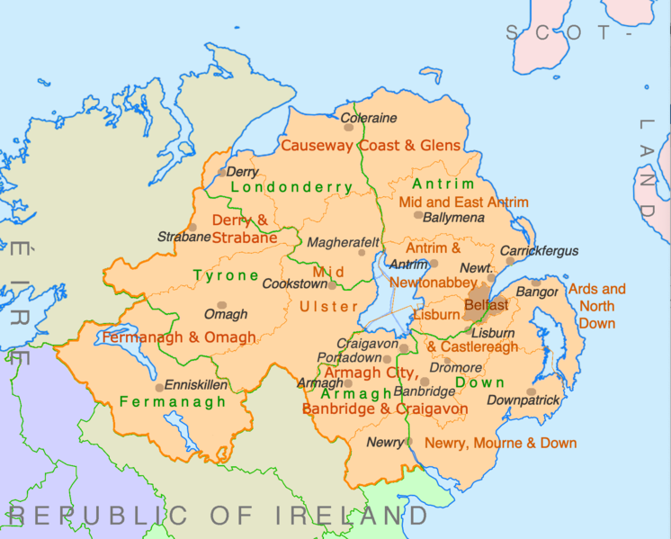
| Aglam | Counties and disticts of Northern Ireland |
| Azemz | |
| Aɣbalu | File:Counties of Ireland.svg & File:United Kingdom Northern Ireland adm location map.svg |
| Ameskar | Ulamm (mmeslay) |
Turagt
Moi, en tant que détenteur des droits d’auteur sur cette œuvre, je la publie sous les licences suivantes :

|
Ɣuṛ-k tasiregt akken ad tneɣleḍ, ad tzuzreḍ neɣ ad tesnifleḍ isemli-agi akken yella di tewtilin n GNU Free Documentation License lqem 1.2 neq yal lqem amaynut i d-yeffɣen sɣuṛ Free Software Foundation, s war abeddel di tgezmiyin, s war aḍris deg usebter amenzu n tdulineɣ s war aḍris deg usebter aneggaru n tduli. Amedya n turagt yedda deg tgezmi ittusemman GNU Free Documentation License. |
This file is licensed under the Creative Commons Attribution-Share Alike 4.0 International, 3.0 Unported, 2.5 Generic, 2.0 Generic and 1.0 Generic license.
- Ɣuṛ-k tilelli:
- i beṭṭu – akken ad tneɣleḍ, ad tzuzreḍ neɣ ad tebḍuḍ amahil-agi
- i uṣeggem – i uṣeggem n umahil
- Ddaw n tiwtilin-agi:
- bab – Yessefk ad d-bedreḍ isem n umeskar aneṣli s wudem yettwammlen sɣuṛ ameskar n umahil neɣ bab n izerfan i k-imudden tasiregt (mačči s wudem yemmalen am akken yettmuddu-yak afus neɣ yeqbel aseqdec-it n umahil).
- bḍut akken yella – Ma tbeddleḍ, teskelteḍ, neɣ tebniḍ ɣef umahil-agi, yessefk ad tezzuzreḍ amahil i d-yeffɣen ɣas ddaw n turagt-nni neɣ turagt icuban ɣuṛ-s.
Tzemreḍ ad ferneḍ yiwet seg turagin-agi.
Amazray n ufaylu
Senned ɣef yiwen azmez d usrag iwakken ad ẓṛeḍ afaylu aken yella deg imir nni.
| Azemz/Ssaɛa | Aqmamaḍ | Iseggiwen | Amseqdac | Awennit | |
|---|---|---|---|---|---|
| Lux a | 9 Yulyu 2022 à 22:28 | | 1 672 × 1 343 (441 KB/KO) | Ulamm | some more names |
| 8 Yulyu 2022 à 22:31 |  | 1 672 × 1 343 (426 KB/KO) | Ulamm | + some places | |
| 6 Yulyu 2022 à 12:38 |  | 1 672 × 1 343 (383 KB/KO) | Ulamm | + Mid Ulster | |
| 6 Yulyu 2022 à 12:03 |  | 1 672 × 1 343 (381 KB/KO) | Ulamm | {{Information |Description=Counties and disticts of Northern Ireland |Source=File:Counties of Ireland.svg & File:United Kingdom Northern Ireland adm location map.svg |Date=2022-07-06 |Author=Ulamm (<span class="signature-talk">{{int:Talkpagelinktext}}</span>) |Permission= |other_versions= }} Category:Maps of Northern Ireland Category:Maps by Ulamm == {{int:license-header}} == {{self|GFDL|cc-by-sa-all|migration=redundant}} |
Aseqdec n ufaylu
Ulaḥedd seg isebtar sɛan azday ar afaylu-agi.
Aseqdec n ufaylu amatu
Iwikiyen-agi-nniḍen seqdacen afaylu-agi:
- Aseqdec ɣef de.wikipedia.org
- Aseqdec ɣef ie.wikipedia.org
- Aseqdec ɣef mt.wikipedia.org