Tugna:Northern Ireland in the UK and Europe.svg

Taille de cet aperçu PNG pour ce fichier SVG : 713 × 600 iferdisen n tugna. Tibuda nniḍen : 285 × 240 iferdisen n tugna | 571 × 480 iferdisen n tugna | 913 × 768 iferdisen n tugna | 1 218 × 1 024 iferdisen n tugna | 2 435 × 2 048 iferdisen n tugna | 2 045 × 1 720 iferdisen n tugna.
Afaylu aneṣli (Afaylu SVG, tabadut n 2 045 × 1 720 pixel, lqedd : 7,84 MB/MO)
Agzul
| Aglam |
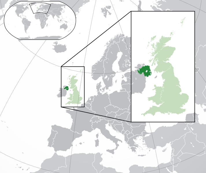
English: A map of Northern Ireland within the United Kingdom and Europe. The map is a polar orthographic projection.
Northern Ireland
Great Britain/United Kingdom except Northern Ireland
Europe (except UK) Français : Une carte de l'Irlande du Nord au sein du Royaume-Uni et en Europe. La carte est un polair projection orthographique.
Irlande du Nord
Grande-Bretagne/Royaume-Unie sauf l'Irlande du Nord
Europe (sauf le Royaume-Unie) Deutsch: Eine Karte der Nordirland drinnen das Vereinigtes Königreich und drinnen Europa. Die Karte ist ein polare orthografische Azimutalprojektion.
Nordirland
Großbritannien/Vereinigtes Königreich außer Nordirland
Europa (außer das Vereinigtes Königreich) Cymraeg:
Gogledd Iwerddon
Y Deyrnas Unedig
Ewrop Gàidhlig:
Èirinn a Tuath
An Rìoghachd Aonaichte
An Roinn-Eòrpa Gaeilge: Tuaisceart Éireann
An Ríocht Aontaithe
An Eoraip |
| Azemz | (UTC) |
| Aɣbalu |
Ce fichier est dérivé de : Blank map of Europe (with disputed regions).svg: |
| Ameskar |
|
| Autres versions |
|
| SVG information | Le code de ce grand fichier SVG n'est pas valide en raison de 201 erreurs. |


.svg)
Turagt
Afaylu-agi yella ddaw n tewtilin n turagt Creative Commons Attribution-Share Alike 3.0 Unported.
- Ɣuṛ-k tilelli:
- i beṭṭu – akken ad tneɣleḍ, ad tzuzreḍ neɣ ad tebḍuḍ amahil-agi
- i uṣeggem – i uṣeggem n umahil
- Ddaw n tiwtilin-agi:
- bab – Yessefk ad d-bedreḍ isem n umeskar aneṣli s wudem yettwammlen sɣuṛ ameskar n umahil neɣ bab n izerfan i k-imudden tasiregt (mačči s wudem yemmalen am akken yettmuddu-yak afus neɣ yeqbel aseqdec-it n umahil).
- bḍut akken yella – Ma tbeddleḍ, teskelteḍ, neɣ tebniḍ ɣef umahil-agi, yessefk ad tezzuzreḍ amahil i d-yeffɣen ɣas ddaw n turagt-nni neɣ turagt icuban ɣuṛ-s.
Journal des téléversements d’origine
This image is a derivative work of the following images:
- File:Blank_map_of_Europe.svg licensed with Cc-by-sa-2.5
- 2012-02-21T16:27:27Z Alphathon 680x520 (614699 Bytes) Updated Metadata and the boarders/coastlines along the western coast of the Black Sea
- 2011-09-19T22:57:58Z Alphathon 680x520 (603759 Bytes) Added North/Northern Cyprus
- 2011-08-23T10:26:48Z Heb 680x520 (604212 Bytes) Added [[:en:Bornholm]] (taken from [[:File:Denmark blank map.svg]])
- 2011-04-12T00:40:40Z Alphathon 680x520 (602549 Bytes) Upgraded Sicily based on "File:Freeworldmaps-sicily.jpg". Upgraded Malta based on "File:Map of Malta 2.png". Simplified Croatian borders.
- 2011-04-10T21:43:04Z Alphathon 680x520 (607359 Bytes) Upgraded Croatia, Bosnia & Herzegovina, Slovenia and surrounding countries based on data from "File:Kroatien - Politische Gliederung (Karte).png"
- 2011-04-10T20:05:09Z Alphathon 680x520 (568373 Bytes) Improved Serbia, Montenegro and surrounding countries using data from "File:Serbia Map.png". Fixed Serbia-Montenegro border. Added Kosovo (using dashed border, since it is not a universally recognised nation, and left the lan
- 2011-04-10T15:55:02Z Alphathon 680x520 (524980 Bytes) Tweaked Ukraine and surrounding countries based on data from "File:Up-map.png"
- 2011-04-10T04:02:09Z Alphathon 680x520 (511168 Bytes) Improved Greece, Albania, F.Y.R. Macedonia and Bulgaria based on "File:Greece topo.jpg"
- 2011-04-10T02:48:52Z Alphathon 680x520 (505569 Bytes) Tweaked Germany and surrounding countries based on info from "File:Germany_general_map.png"
- 2011-04-10T01:54:05Z Alphathon 680x520 (493733 Bytes) Converted all lakes back to separate layer. Added Finish lakes and tweaked Finland shape based on "File:Finland 1996 CIA map.jpg". Added Swiss lakes based on "File:Suisse cantons.svg". Tweaked Scotland and added Lochs.
- 2011-04-10T00:07:54Z Alphathon 680x520 (450120 Bytes) Improved England outline and added Isle of Wight based on "File:England Regions - Blank.svg". Improved Denmark based on "File:2 digit postcode danmark.png". Improved Sweden based on "File:Map of Sweden, CIA, 1996.jpg"
- 2011-04-08T15:53:07Z Alphathon 680x520 (438878 Bytes) Upgraded/fixed various parts of the map. Details: *Some minor fixes to Ireland and added some of the larger lakes based on [[:File:Ireland_trad_counties_named.svg]] *Pretty major fixes to Scotland (mainly the west coast and i
- 2008-09-17T09:50:25Z F7 680x520 (531491 Bytes)
- 2008-09-17T09:42:57Z F7 680x520 (2353 Bytes)
- 2008-05-26T19:04:07Z Collard 680x520 (531491 Bytes) uploading on behalf of [[User:Checkit]], direct complaints to him plox: 'Moved countries out of the "outlines" group, removed "outlines" style class, remove separate style information for Russia'
- 2008-04-30T01:38:52Z TimothyBourke 680x520 (531767 Bytes) Changed the country code of Serbia to RS per [http://en.wikipedia.org/wiki/Serbian_country_codes] and the file [http://www.iso.org/iso/iso3166_en_code_lists.txt].
- 2008-02-08T22:44:37Z CarolSpears 680x520 (531767 Bytes) validated
- 2007-07-10T11:47:59Z MrWeeble 680x520 (533112 Bytes) Updated to include British Crown Dependencies as seperate entities and regroup them as "British Islands", with some simplifications to the XML and CSS
- 2007-05-14T17:17:34Z Zirland 680x520 (540659 Bytes) serbia and montenegro
- 2007-03-30T20:40:49Z W!B: 680x520 (538830 Bytes) minor corr: update nl:Ijsselmeer, del fi:lakes (all small), add ru:lake Oneka (all ref maps.google), glued northern irland back to ie ;)
- 2007-02-05T18:44:32Z Maix 680x520 (538295 Bytes) cropped
- 2007-02-04T15:07:29Z Maix 680x520 (538310 Bytes) {{Information |Description=A blank Map of Europe in SVG format. Every country has an id which is its ISO-3116-1-ALPHA2 code in lower case for easy coloring. |Source=Image based on [[Image:Europe_countries.svg|]] by [[User:Ti
Téléversé avec derivativeFX
Amazray n ufaylu
Senned ɣef yiwen azmez d usrag iwakken ad ẓṛeḍ afaylu aken yella deg imir nni.
| Azemz/Ssaɛa | Aqmamaḍ | Iseggiwen | Amseqdac | Awennit | |
|---|---|---|---|---|---|
| Lux a | 6 Ɣuct 2014 à 20:00 | | 2 045 × 1 720 (7,84 MB/MO) | Rob984 | Improved version: More accurate coastline, borders, etc. Added Gradient and Longitude and latitude lines. Zoom insert centred on UK. |
| 21 Fuṛaṛ 2014 à 14:57 |  | 680 × 520 (2,48 MB/MO) | Rob984 | White background so that the edge of the map is clear. Consistency with other European countries' maps also. | |
| 19 Yennayer 2013 à 18:24 |  | 680 × 520 (2,46 MB/MO) | Alphathon | Added Robinson projection to top left corner. | |
| 26 Fuṛaṛ 2012 à 23:38 |  | 680 × 520 (941 KB/KO) | Alphathon | Fixed XML | |
| 26 Fuṛaṛ 2012 à 23:34 |  | 680 × 520 (941 KB/KO) | Alphathon | More detailed version of the British Isles | |
| 26 Fuṛaṛ 2012 à 00:36 |  | 680 × 520 (789 KB/KO) | Alphathon | Added missing parts of Belgium and the Netherlands. | |
| 25 Fuṛaṛ 2012 à 22:36 |  | 680 × 520 (806 KB/KO) | Alphathon | == {{int:filedesc}} == {{Information |Description={{en|A map of Northern Ireland (dark green) within the United Kingdom (dark and light green) and Europe (dark green, light green and darker grey).}} |Source={{Derived from|Blank_map_of_Europe.svg|displa... |
Aseqdec n ufaylu
Asebter agi teseqdac afaylu agi :
Aseqdec n ufaylu amatu
Iwikiyen-agi-nniḍen seqdacen afaylu-agi:
- Aseqdec ɣef af.wikipedia.org
- Aseqdec ɣef af.wiktionary.org
- Aseqdec ɣef am.wikipedia.org
- Aseqdec ɣef ang.wikipedia.org
- Aseqdec ɣef ar.wikipedia.org
- Aseqdec ɣef arz.wikipedia.org
- Aseqdec ɣef az.wikipedia.org
- Aseqdec ɣef be-tarask.wikipedia.org
- Aseqdec ɣef be.wikipedia.org
- Aseqdec ɣef bg.wikipedia.org
- Aseqdec ɣef bh.wikipedia.org
- Aseqdec ɣef blk.wikipedia.org
- Aseqdec ɣef bn.wikipedia.org
- Aseqdec ɣef bs.wikipedia.org
- Aseqdec ɣef bxr.wikipedia.org
- Aseqdec ɣef ca.wikipedia.org
- Aseqdec ɣef cdo.wikipedia.org
- Aseqdec ɣef chy.wikipedia.org
- Aseqdec ɣef diq.wikipedia.org
- Aseqdec ɣef el.wikipedia.org
- Aseqdec ɣef en.wikipedia.org
- Aseqdec ɣef en.wikinews.org
- Aseqdec ɣef eo.wikipedia.org
- Aseqdec ɣef es.wikipedia.org
- Aseqdec ɣef et.wikipedia.org
- Aseqdec ɣef fa.wikipedia.org
- Aseqdec ɣef fa.wikivoyage.org
- Aseqdec ɣef fi.wikipedia.org
- Aseqdec ɣef fr.wikipedia.org
Wali l’utilisation globale n ufaylu-agi.