Tugna:Greater london outline map bw.png
Ulac tabadut tameqqṛant i yellan.
Greater_london_outline_map_bw.png (600 × 500 pixel, tiddi n ufaylu: 199 KB/KO, anaw n MIME: image/png)

|
Une version vectorielle de cette image existe, dans le format « SVG ». Si elle n’est pas inférieure, elle devrait être utilisée à la place de la présente version pour des affichages en plus grandes dimensions ou nécessitant une meilleure résolution.
File:Greater london outline map bw.png → File:Greater London UK location map 2.svg
Pour plus d’informations sur les images vectorielles, consultez la page de transition de Commons vers le format SVG. Voir aussi les informations à propos de la manière dont le logiciel MediaWiki gère les images au format SVG. |
 |
Agzul
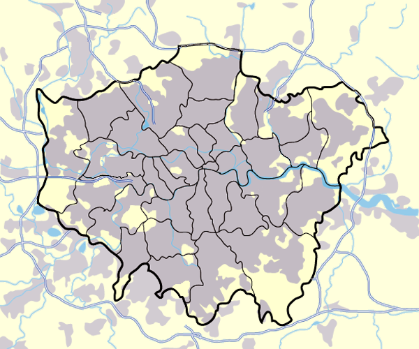
Image:Greater_london_outline_map.png showing built up areas in grey, motorways in blue, water-bodies in light-blue and London borough and county boundaries in black.
Based on a map originally by User:ChrisO.
Revised to correct motorways. DavidCane 19:42, 31 March 2007 (UTC)
Turagt

|
Ɣuṛ-k tasiregt akken ad tneɣleḍ, ad tzuzreḍ neɣ ad tesnifleḍ isemli-agi akken yella di tewtilin n GNU Free Documentation License lqem 1.2 neq yal lqem amaynut i d-yeffɣen sɣuṛ Free Software Foundation, s war abeddel di tgezmiyin, s war aḍris deg usebter amenzu n tdulineɣ s war aḍris deg usebter aneggaru n tduli. Amedya n turagt yedda deg tgezmi ittusemman GNU Free Documentation License. |
| Afaylu-agi yella ddaw n tewtilin n turagt Creative Commons Attribution-Share Alike 3.0 Unported. | ||
| ||
| Ce bandeau de licence a été ajouté à ce fichier dans le cadre de la procédure de mise à jour des licences des images sous GFDL. |
| Annotations | This image is annotated: View the annotations at Commons |
Amazray n ufaylu
Senned ɣef yiwen azmez d usrag iwakken ad ẓṛeḍ afaylu aken yella deg imir nni.
| Azemz/Ssaɛa | Aqmamaḍ | Iseggiwen | Amseqdac | Awennit | |
|---|---|---|---|---|---|
| Lux a | 11 Meɣres 2008 à 17:13 | | 600 × 500 (199 KB/KO) | Jza84 | slight alteration making the boundaries clearer between Newham and Barking and Dagenham - Ealing and Hounslow - and City of London and the City of Westminster |
| 31 Meɣres 2007 à 19:40 |  | 600 × 500 (217 KB/KO) | DavidCane | ||
| 19 Meɣres 2007 à 14:33 |  | 600 × 500 (512 KB/KO) | Jza84 | minor colour correction | |
| 19 Meɣres 2007 à 14:30 |  | 600 × 500 (512 KB/KO) | Jza84 | yellowed white backdrop and altered blue of water bodies inline with UK mapping | |
| 15 Meɣres 2007 à 11:16 |  | 600 × 500 (552 KB/KO) | Jza84 | Corrected some issues with Motorways and borough boundaries. | |
| 25 Fuṛaṛ 2007 à 19:22 |  | 600 × 500 (476 KB/KO) | Jza84 | Map of Greater London and area. Self made and released to public domain. | |
| 18 Wamber 2006 à 18:09 |  | 600 × 500 (21 KB/KO) | Dtcdthingy~commonswiki | Image:Greater_london_outline_map.png with toned down colour scheme. Originally by User:ChrisO. |
Aseqdec n ufaylu
Ulaḥedd seg isebtar sɛan azday ar afaylu-agi.
Aseqdec n ufaylu amatu
Iwikiyen-agi-nniḍen seqdacen afaylu-agi:
- Aseqdec ɣef ast.wikipedia.org
- Aseqdec ɣef be.wikipedia.org
- Aseqdec ɣef bg.wikipedia.org
- Aseqdec ɣef ca.wikipedia.org
- Aseqdec ɣef da.wikipedia.org
- EFL League Championship
- Brugerdiskussion:Lindberg
- Westminster
- Charing Cross
- Skabelon:Kortpositioner Greater London
- Seven Sisters
- Tottenham
- Premier League
- Chelsea (London)
- Premier League 2013-14
- Premier League 2014-15
- Premier League 2015-16
- Attentatet i Finsbury Park 2017
- Premier League 2016-17
- The Football League 1927-28
- The Football League 1928-29
- The Football League 1929-30
- The Football League 1930-31
- The Football League 1931-32
- The Football League 1932-33
- Aseqdec ɣef de.wikipedia.org
- Aseqdec ɣef en.wikipedia.org
- Aseqdec ɣef en.wikinews.org
- Aseqdec ɣef eo.wikipedia.org
- Aseqdec ɣef es.wikipedia.org
- Aseqdec ɣef eu.wikipedia.org
- Aseqdec ɣef fa.wikipedia.org
- Aseqdec ɣef fr.wikipedia.org
- Aseqdec ɣef gu.wikipedia.org
- Aseqdec ɣef hy.wikipedia.org
Wali l’utilisation globale n ufaylu-agi.