Tugna:Topography of Ireland.jpg

Tiddi n azaraskan agi : 474 × 600 iferdisen n tugna. Tibuda nniḍen : 190 × 240 iferdisen n tugna | 379 × 480 iferdisen n tugna | 607 × 768 iferdisen n tugna | 809 × 1 024 iferdisen n tugna | 1 618 × 2 048 iferdisen n tugna | 3 293 × 4 168 iferdisen n tugna.
Afaylu aneṣli (3 293 × 4 168 pixel, tiddi n ufaylu: 3,86 MB/MO, anaw n MIME: image/jpeg)
Agzul
| Aglam |
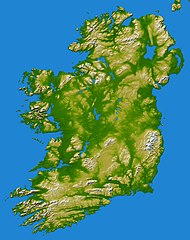
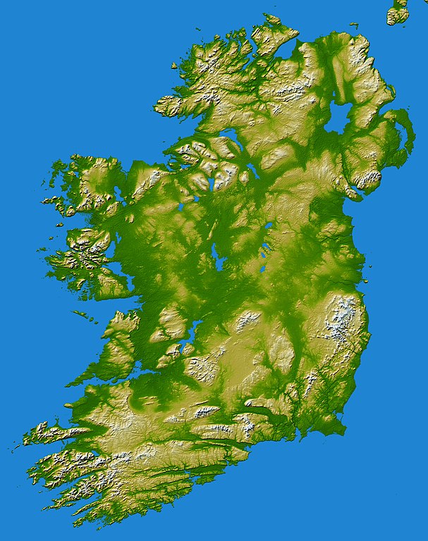
earthobservatory.nasa.gov/IOTD/view.php?id=5343 Elevation data used in this image were acquired by the Shuttle Radar Topography Mission aboard the Space Shuttle Endeavour, launched on Feb. 11, 2000. SRTM used the same radar instrument that comprised the Spaceborne Imaging Radar-C/X-Band Synthetic Aperture Radar (SIR-C/X-SAR) that flew twice on the Space Shuttle Endeavour in 1994. SRTM was designed to collect 3-D measurements of the Earth's surface. To collect the 3-D data, engineers added a 60-meter (approximately 200-foot) mast, installed additional C-band and X-band antennas, and improved tracking and navigation devices. The mission is a cooperative project between NASA, the National Geospatial-Intelligence Agency (NGA) of the U.S. Department of Defense and the German and Italian space agencies. It is managed by NASA's Jet Propulsion Laboratory, Pasadena, Calif., for NASA's Earth Science Enterprise, Washington, D.C.Topography of Ireland - Feb 2000 |
| Azemz | |
| Aɣbalu | Flickr |
| Ameskar | Danny McL de Whitechapel, London, UK |
| Reviewer | File Upload Bot (Magnus Manske) |
Turagt
Ce fichier est disponible selon les termes de la licence Creative Commons Attribution – Partage dans les Mêmes Conditions 2.0 Générique
- Ɣuṛ-k tilelli:
- i beṭṭu – akken ad tneɣleḍ, ad tzuzreḍ neɣ ad tebḍuḍ amahil-agi
- i uṣeggem – i uṣeggem n umahil
- Ddaw n tiwtilin-agi:
- bab – Yessefk ad d-bedreḍ isem n umeskar aneṣli s wudem yettwammlen sɣuṛ ameskar n umahil neɣ bab n izerfan i k-imudden tasiregt (mačči s wudem yemmalen am akken yettmuddu-yak afus neɣ yeqbel aseqdec-it n umahil).
- bḍut akken yella – Ma tbeddleḍ, teskelteḍ, neɣ tebniḍ ɣef umahil-agi, yessefk ad tezzuzreḍ amahil i d-yeffɣen ɣas ddaw n turagt-nni neɣ turagt icuban ɣuṛ-s.
| This image, originally posted to Flickr, was reviewed on May 31, 2010 by the administrator or reviewer File Upload Bot (Magnus Manske), who confirmed that it was available on Flickr under the stated license on that date. |
Amazray n ufaylu
Senned ɣef yiwen azmez d usrag iwakken ad ẓṛeḍ afaylu aken yella deg imir nni.
| Azemz/Ssaɛa | Aqmamaḍ | Iseggiwen | Amseqdac | Awennit | |
|---|---|---|---|---|---|
| Lux a | 31 Mayyu 2010 à 07:27 | | 3 293 × 4 168 (3,86 MB/MO) | File Upload Bot (Magnus Manske) | {{Information |Description=[http://earthobservatory.nasa.gov/IOTD/view.php?id=5343 earthobservatory.nasa.gov/IOTD/view.php?id=5343] Elevation data used in this image were acquired by the Shuttle Radar Topography Mission aboard the Space Shuttle Endeavour |
Aseqdec n ufaylu
Asebter agi teseqdac afaylu agi :
Aseqdec n ufaylu amatu
Iwikiyen-agi-nniḍen seqdacen afaylu-agi:
- Aseqdec ɣef an.wikipedia.org
- Aseqdec ɣef de.wikibooks.org
- Aseqdec ɣef gv.wikipedia.org
- Aseqdec ɣef hu.wikipedia.org