Tugna:Philadelphia skyline from South Street Bridge January 2020 (rotate 2 degrees perspective correction crop 4-1).jpg

Tiddi n azaraskan agi : 800 × 200 iferdisen n tugna. Tibuda nniḍen : 320 × 80 iferdisen n tugna | 640 × 160 iferdisen n tugna | 1 024 × 256 iferdisen n tugna | 3 816 × 954 iferdisen n tugna.
Afaylu aneṣli (3 816 × 954 pixel, tiddi n ufaylu: 1,42 MB/MO, anaw n MIME: image/jpeg)
Agzul
| Aglam |
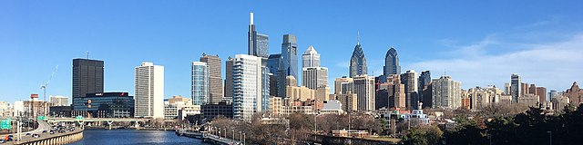
English: The skyline of Philadelphia, Pennsylvania viewed from the South Street Bridge over the Schuylkill River. If on Wikipedia, see the fully annotated version on the Wikimedia page.
|
||
| Azemz | |||
| Aɣbalu | File:Philadelphia_skyline_from_South_Street_Bridge_January_2020.jpeg | ||
| Ameskar | Dough4872; modifications and annotations by Maps and stuff (Brian W. Schaller) | ||
| Autres versions |
|

.jpg)
| Lieu de la prise de vue | | Voir cet endroit et d’autres images sur : OpenStreetMap |
|---|
.jpg¶ms=039.946975_N_-075.186797_E_globe:Earth_type:camera_heading:69.51&language=kab)
Turagt
Ce fichier est sous la licence Creative Commons Attribution – Partage dans les Mêmes Conditions 4.0 International.
- Ɣuṛ-k tilelli:
- i beṭṭu – akken ad tneɣleḍ, ad tzuzreḍ neɣ ad tebḍuḍ amahil-agi
- i uṣeggem – i uṣeggem n umahil
- Ddaw n tiwtilin-agi:
- bab – Yessefk ad d-bedreḍ isem n umeskar aneṣli s wudem yettwammlen sɣuṛ ameskar n umahil neɣ bab n izerfan i k-imudden tasiregt (mačči s wudem yemmalen am akken yettmuddu-yak afus neɣ yeqbel aseqdec-it n umahil).
- bḍut akken yella – Ma tbeddleḍ, teskelteḍ, neɣ tebniḍ ɣef umahil-agi, yessefk ad tezzuzreḍ amahil i d-yeffɣen ɣas ddaw n turagt-nni neɣ turagt icuban ɣuṛ-s.
| Annotations | This image is annotated: View the annotations at Commons |
Amazray n ufaylu
Senned ɣef yiwen azmez d usrag iwakken ad ẓṛeḍ afaylu aken yella deg imir nni.
| Azemz/Ssaɛa | Aqmamaḍ | Iseggiwen | Amseqdac | Awennit | |
|---|---|---|---|---|---|
| Lux a | 27 Yennayer 2020 à 14:22 | 3 816 × 954 (1,42 MB/MO) | Maps and stuff | User created page with UploadWizard |
Aseqdec n ufaylu
Asebter agi teseqdac afaylu agi :
Aseqdec n ufaylu amatu
Iwikiyen-agi-nniḍen seqdacen afaylu-agi:
- Aseqdec ɣef ang.wikipedia.org
- Aseqdec ɣef ar.wikipedia.org
- Aseqdec ɣef arz.wikipedia.org
- Aseqdec ɣef ast.wikipedia.org
- Aseqdec ɣef br.wikipedia.org
- Aseqdec ɣef ca.wikipedia.org
- Aseqdec ɣef ce.wikipedia.org
- Aseqdec ɣef ckb.wikipedia.org
- Aseqdec ɣef cy.wikipedia.org
- Aseqdec ɣef da.wikipedia.org
- Aseqdec ɣef de.wikivoyage.org
- Aseqdec ɣef diq.wikipedia.org
- Aseqdec ɣef en.wikipedia.org
- Aseqdec ɣef en.wikibooks.org
- Aseqdec ɣef en.wikivoyage.org
- Aseqdec ɣef eu.wikipedia.org
- Aseqdec ɣef fr.wikivoyage.org
- Aseqdec ɣef ga.wikipedia.org
- Aseqdec ɣef gl.wikipedia.org
- Aseqdec ɣef ha.wikipedia.org
- Aseqdec ɣef he.wikivoyage.org
- Aseqdec ɣef ht.wikipedia.org
- Aseqdec ɣef ia.wikipedia.org
- Aseqdec ɣef ilo.wikipedia.org
- Aseqdec ɣef incubator.wikimedia.org
- Aseqdec ɣef it.wikipedia.org
- Aseqdec ɣef it.wikivoyage.org
- Aseqdec ɣef ja.wikivoyage.org
- Aseqdec ɣef lb.wikipedia.org
- Aseqdec ɣef lld.wikipedia.org
- Aseqdec ɣef mhr.wikipedia.org
- Aseqdec ɣef no.wikipedia.org
- Aseqdec ɣef ru.wikipedia.org
- Aseqdec ɣef ru.wikinews.org
- Aseqdec ɣef simple.wikipedia.org
- Aseqdec ɣef sr.wikipedia.org
Wali l’utilisation globale n ufaylu-agi.
.jpg)
.jpg)